Posts Tagged ‘Port Mellon’
The Missing Link: Connecting the Coast to Squamish
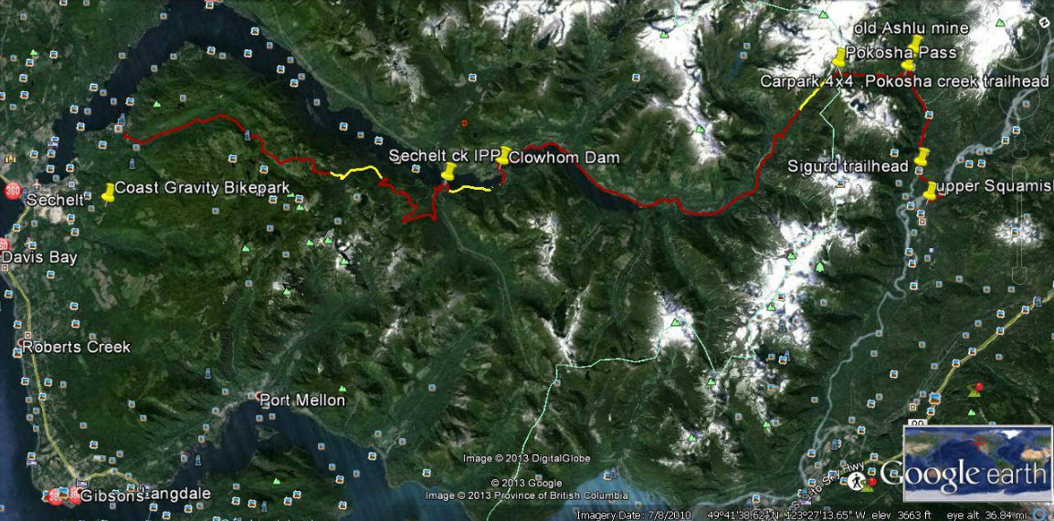
Yellow sections on this Google Earth map indicate about 10 kilometres of work needed to complete a trail connecting Sechelt with Squamish.
The map looks straightforward at first. As the crow flies, little more than 50 kilometres separate Sechelt and Squamish. Then you notice contour lines, crammed together like intense low-pressure systems, numerous splashes of white, indicating icy peaks, and deep blue streaks showing alpine lakes and ocean inlets. In between are green valleys that never seem to quite connect. Old logging roads, new hydroelectric projects, powerlines and pipelines present an extra layer of complexity revealed by Google Earth.
A cursory Internet search turns up more than 100 years of failed attempts to build a road system between the Sunshine Coast and “the mainland”.
So when Geoff Breckner tells me he’s about 10 kilometres away from completing a 75-kilometre trail connector, I’m interested.
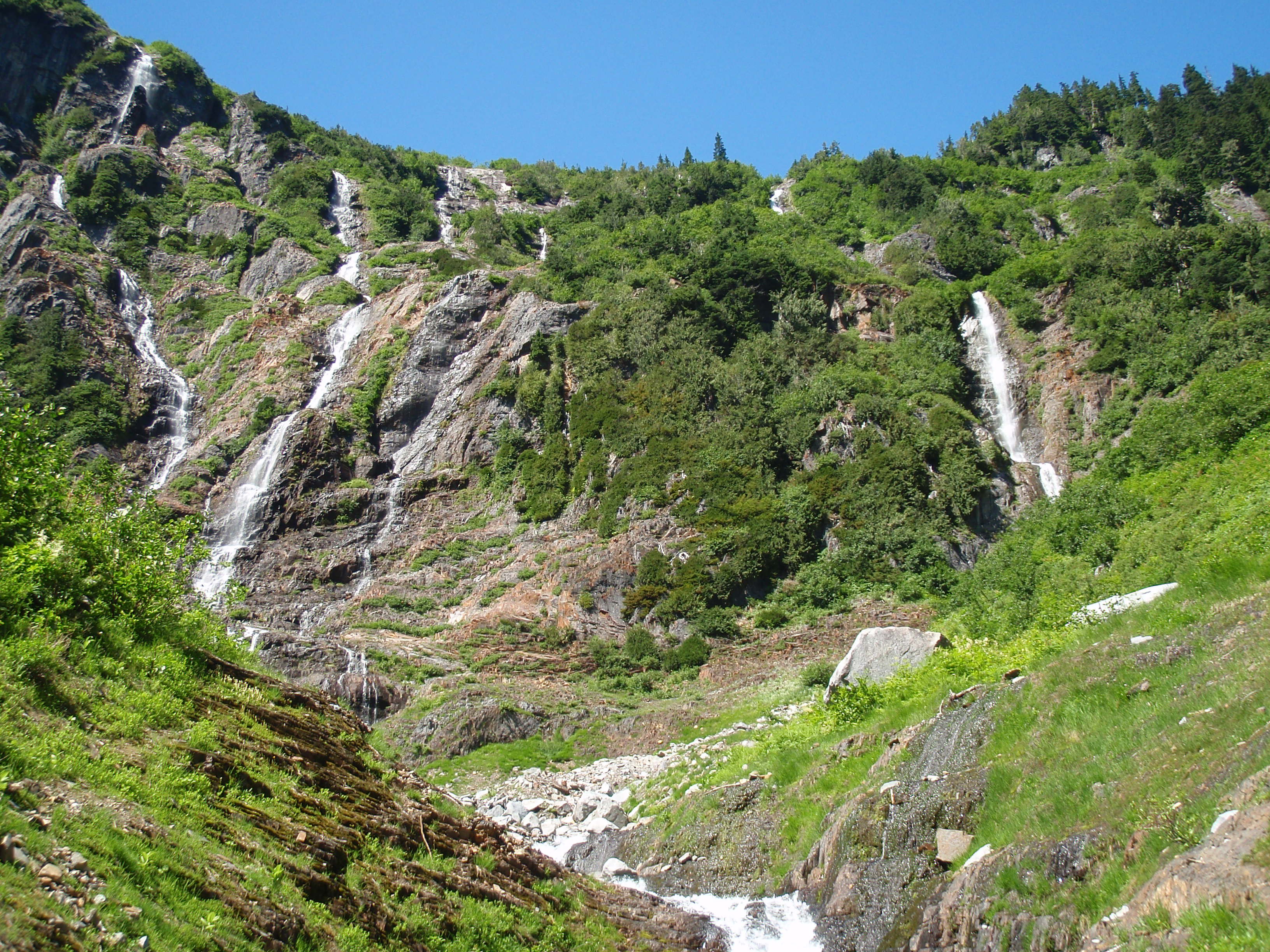
If successful, the trail would reveal a side of the Sunshine Coast unfamiliar to most residents, including a series of spectacular waterfalls between Pokosha Pass and Clowhom Valley. All photos courtesy Geoff Breckner
“With 10 capable guys and permission it could be finished in a week or two,” Breckner tells me by phone from Squamish. “But there are channels to go through, rules to be followed … funding.”
Breckner is recovering from major back surgery. When his doctor advised him to exercise he began hiking into the backcountry near his home in Squamish. The 53-year-old estimates he spent 200 hours during the last two summers working on the Squamish end of the trail.
A self-described “mountainbiking nut,” and “bush rat,” Breckner grew up in Deep Cove when the sport was still a novelty. He opened Pemberton’s first bike store, High Line Cycles, in 1994. A trail connecting Squamish with the Sunshine Coast makes a lot of sense, he says.
“I thought this was a great place for a bike trail. I knew there were logging roads up there and I researched as much as I could, checking out the feasibility of a route to Sechelt.”

Geoff Breckner’s tent at the south side of Pokosha Pass, near Mount Jimmy Jimmy.
Visit Breckner’s Facebook site ‘Squamish to Sechelt Trail’ and you’ll see a Google Earth image of the proposed route. From Upper Squamish and the Ashlu River Road, the route first heads north over existing trail through 4,000-foot Pokosha Pass before heading south, then due west following Clowhom Lake to Salmon Inlet, skirting the Tetrahedron Provincial Park, and on towards Sechelt via the Coast Gravity Bike Park.
About 55 kilometres of double track roads, and 20 kilometres of single track trails make up the route, says Breckner. The 10 kilometres still to be cleared comprise three sections of one kilometer, four kilometres and five kilometres.
“Once complete, it would be a long ride – two days for most people, but I hope to have a hut or shelter so people don’t need a tent and can travel light,” says Breckner. “The main problem would be lack of use, rather than overuse. The more use the better, to keep trail maintained and established.”
Breckner has received numerous offers of help from this side of the divide. Doug Feniak of Tillicum Bay is among those pledging assistance.

A self-described mountainbiking nut, Geoff Breckner rarely goes anywhere without his ride.
Feniak grew up riding with Breckner in Deep Cove. “It was a dream of ours when we were young, to be able to ride from Squamish to the Coast,” says Feniak. “We hiked into the Tetrahedron in August, looking for the best way. It’s super steep into Thornhill Creek but it shouldn’t be too bad after that because it’s old roads covered with Alders.”
Trails are in the Feniak family’s blood. Wife Jessica Huntington and son Linden both build trails, the latter professionally. Daughter, Holly, was 2012 downhill mountainbike Junior World Champion.
Doug says he expects to have a group working on this end of the trail in the fall.
“It would certainly be good for tourism here and I could see the B.C. Bike Race using it,” says Feniak.
Long-time local trailbuilder, Richard Culbert, says a trail to Squamish is “common sense”.
Culbert built the trail to the summit of Mt. Elphinstone, opening it on his 70th birthday. Now at 75, he’s busy clearing a trail up 4,700-foot Polytope Peak, which connects with Rainy River Road and Port Mellon due south. He believes that a trail from Squamish stands a better chance of completion if it veers south to Port Mellon, rather than to Sechelt.

Salmon Inlet from the top of Gray Creek Forest Service Road, looking north across Thornhill towards Clowhom valley. It’s about 60km from here to upper Squamish.
“The trail I’m working on is about a kilometer from a logging road, which appears to connect with this route,” says Culbert pointing at a printed version of Breckner’s route. “It also avoids Thornhill Creek [near Salmon Inlet] where the road is covered in alders.”
Warren Hansen concurs. “That gap after Salmon Inlet is some of the most rugged terrain I’ve ever walked in,” says Hansen, forester/area manager for Chartwell Consultants and an avid trailbuilder. “A lot of that area was logged in the 60s and 70s, so we’re talking about logging roads half a century old – many of which have been heavily deactivated and are covered in alder.
“I admire following an idea, but I worry about the sustainability of it,” adds Hansen. “The skeptical side of me thinks that there won’t be enough people using it. It will need to be on a lot of people’s bucket lists to make it sustainable.”
Hansen identifies with Breckner on one level.
“I believe in unfettered access to crown land. You live in the city, you can’t do this and that, but you have spoon-fed amenities. In a rural environment you don’t have those amenities, but you do have unfettered access to crown land. You can hike it, bike it, pick mushrooms in it, build trails. So you use it as you see fit, knowing that one day, it might be logged.”
Perhaps the person most excited about a possible connection is Bjorn Enga. The Granthams Landing-based filmmaker is the founder of Kranked, an online store for electric-assisted mountainbikes. They may upset purists, but bikes capable of climbing mountains in minutes, as opposed to hours, are catching on, says Enga.
“I’ve been riding on the Coast since 2000, and it’s an amazing coastline,” he says. “Suddenly, I’m thinking how much more I can see up there riding an e-bike. Imagine how phenomenal it would be to offer overnight tours with a fully charged battery for the next day.
“The Sea-to-Sky Corridor could become the e-bike capital of the world.”
Enga is helping Breckner with route planning and believes that trail completion is a matter of when, not if.
“Geoff goes way back to the start of mountainbike culture, before the glamour of the parks,” says Enga. “He’s done the hard part and one way or another, the trail will happen.”
In the meantime, some adventurers will continue to blaze their own trails. It seems as though everyone on the Sunshine Coast knows “a guy” who knows a route to Squamish. But their identity can be as elusive as the route.

More falls in the backcountry between Squamish and the Sunshine Coast.
Not so, Todd Lawson and friends, whose epic three-day trek from Lake Lovely Water, Squamish, to Sechelt via Clowhom Lake and Salmon Inlet, was featured in a 2014 issue of Mountain Life magazine. The trio packed inflatable stand-up paddleboards for the trip, which featured untold hours of bushwhacking through endless alder roots and Devil’s Club – an experience Lawson described in the story as “torture”. (He also wrote of the route, “It looked good on a laptop.”)
A different hazard awaited Denis Rogers of Sechelt, and fellow Coasters Mark Guignard and Al Jenkins, who hiked to Squamish in 2004 after being dropped by boat at the head of Narrows Inlet.
“It took us five days,” says Rogers, whose group followed a route from the head of Tzoonie Valley to a 4,800-foot pass, and then down to Falk Creek and a logging road leading to the Ashlu River and Squamish beyond.
“The third day was an interesting one,” recalls Rogers. “I fell in a lake and broke my watch, and Mark, the only one of us who didn’t bring bear spray, had an encounter with a black bear. Mark was about 20 yards ahead of us, picking his way through the boulders, when we shouted to him that a bear was taking an interest in him.
“The bear started down towards him, but then turned back. We suggested that perhaps the bear had been deterred by an offensive smell.”
Some hazards you won’t find on any map.
- To contact Geoff Breckner, email capnbreak@yahoo.ca or visit his Facebook site, Squamish to Sechelt Trail.
