Posts Tagged ‘backcountry’
Going downhill. Fast!
“Tobogganing, which has sprung into such sudden popularity, is only a form of coasting. There is no more exciting and exhilarating sport for ladies and gentlemen than this on a clear, cold winter evening.”
- Modern Manners and Social Forms: A Manual of the Manners and Customs of the Best Modern Society, James Bethuel Smiley, 1890

On the eastern slopes of Dakota Ridge, Emma Judd prepares for takeoff!
Even down at sea level and despite its name, the Sunshine Coast is no stranger to snow. Anyone who has grown up here can attest to cold snaps and snow days. Despite claiming to be 29, my mum-in-law Mary Vandeberg recalls the winter of 1954 vividly.
“We spent a lot time tobogganing down Davis Bay hill that winter,” says Mary. “We had spotters, but there really wasn’t much traffic to speak of in those days. And if there was, it wasn’t getting up that hill.”

Trouble with a capital T, Mary Vandeberg with her sister Gail somewhere on a road near Davis Bay, circa 1954.
For Mary’s daughter, my wife Leah, tobogganing the road down from Chatelech Secondary, was the ultimate way to celebrate a snow day.
Even in the snowiest winters of recent years, it’s difficult to image tobogganing Highway 101 from Selma Park down to Davis Bay, as Mary describes. But that doesn’t mean there aren’t plenty of other popular places to slide.
Located 14-km up the forest service road at the end of Field Road in Wilson Creek, Dakota Ridge is one of the few, if not the only sanctioned sliding area on the Sunshine Coast. Created in 2013, the sliding area has become a popular addition to the winter recreation venue, accounting for 30 percent of total traffic, according to the Sunshine Coast Regional District.
Especially popular with young families, the groomed hill is right behind a Quonset warming hut, which is equipped with a wood stove and picnic tables. If you’re craving some off-piste thrills, there’s a long, gentle clearing off Balsam Loop on Dakota Ridge’s eastern slope that’s perfect for building bumps and jumps.

We have liftoff! Ariana Harder takes to the skies above Dakota Ridge.
Local Cavin Crawford, who’s helped plow access roads to Dakota Ridge and the Tetrahedron for years, recommends a 200-metre slope at the eight-kilometre mark of the forestry road, near the turnoff for Dakota Bowl.
“You can drive up around the corner, let the kids out and drive down and pick them up,” says Cavin. “But please, do not toboggan on the road.”
Winter tires and chains are essential, if you’re planning to drive to Dakota Ridge; or catch the scheduled shuttle with Wilson Creek-based Alpha Adventures.
Closer to sea level, school fields are popular with the younger crowd. “The slope behind Gibsons elementary is good for younger kids and pretty good for building jumps,” says 12-year-old Kaishan Nonacowie. There’s also a gentle slope behind Elphinstone Secondary.
Flume Beach Park at the junction of Flume Road and Beach Avenue in Roberts Creek might be the closest you’ll get to sledding on the shoreline. It was a favourite spot when my kids were growing up and offers the added advantage of a scenic picnic area, plus the option of building a beach fire to warm up by.

In their element, Ariana Harder and Emma Judd on Dakota Ridge.
A poll of friends and family on Facebook elicited numerous favourite spots and a theme quickly developed: roads seem to be where it’s at. Some short, some steep, and most dead-ends. (My son suggested School Road in Gibsons, which might have been feasible in 1917-18, but not 2017-18.) While there’s room for discretion on secluded roads in particularly heavy snowfalls, as a rule, cars and toboggans don’t mix, especially for emergency services, highway maintenance contractors, and stranded residents.
Back in the 1970s, it was a different story, according to life-long Coast resident, Warren Hansen.
“My favourite hill was Benner Road, in Selma Park,” recalls Warren. “Back then, there was no such things as immediate plowing. People had to park on the highway in Selma Park and walk up to their homes. For at least a couple of days, kids could slide down Benner Road, or the top of Snodgrass and Chartwell, or the top of Radcliffe Road. Every kid from miles around would converge on this location.
“I remember a bunch of us piled on a toboggan racing other toboggans down the hill. We knew that once we passed a certain driveway it was time to bail otherwise we would blow the corner and get hurt. And most kids did get hurt from getting run into, going into the ditch, or bailing off the sled sliding at breakneck speeds.”
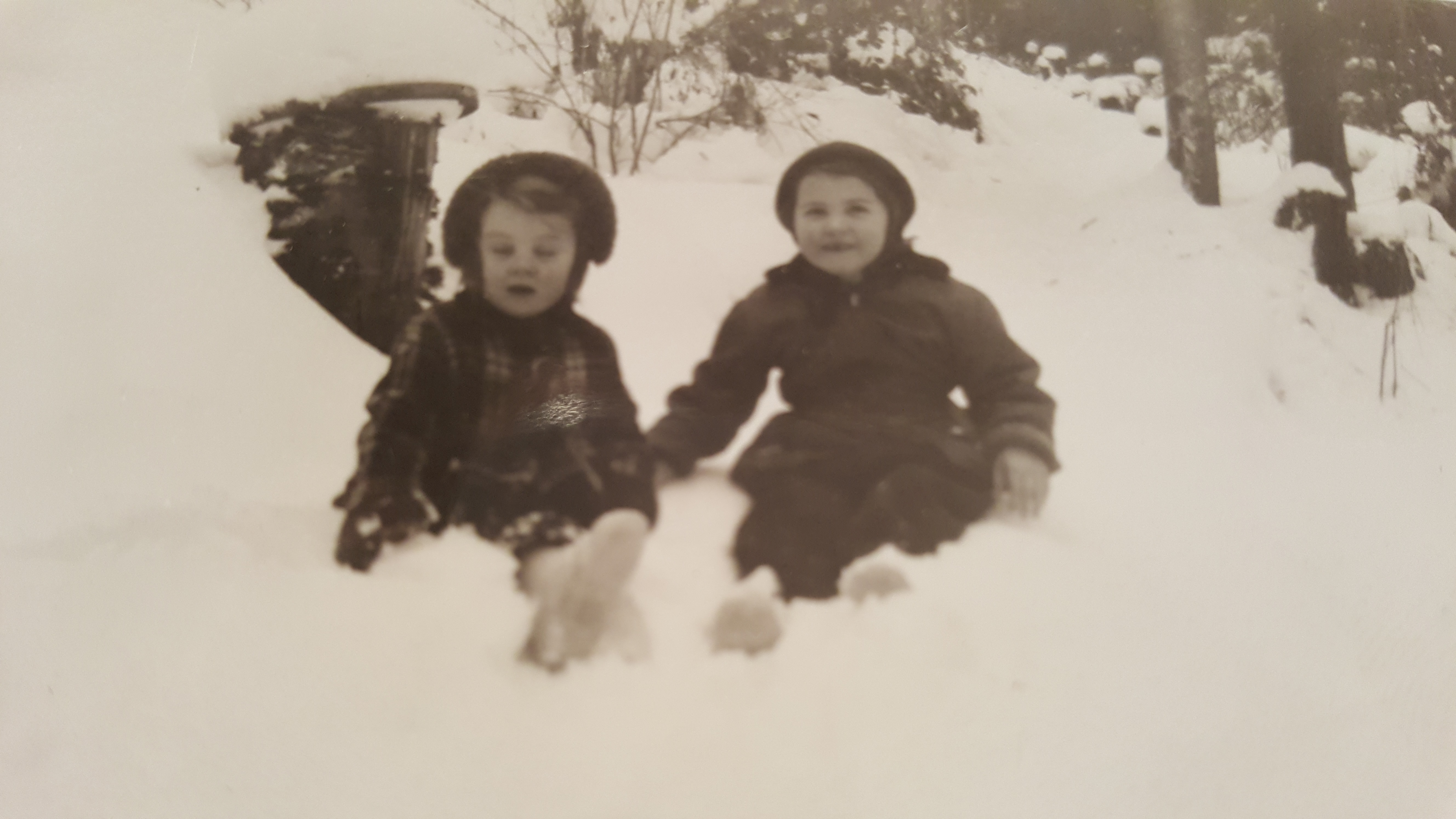
Mary Vandeberg and her sister Gail in the snowy Sunshine Coast winter of 1954.
Hansen acknowledges those days are over, but has mixed feelings.
“The plows, climate change and over-sensitive parents ruined the great sliding opportunities on Benner Road, which hasn’t been the same since those days. Then again, it could be because I grew up and know now that I would never let my kids slide on Benner Road.”
Wherever you end up sliding this winter, keep a few precautions in mind. BC Children’s Hospital recommends that young ones wear a ski, hockey, or bike helmet for tobogganing. Make sure your kids know how to control their speed and stop properly. Choose a slope away from roads and free from obstacles, such as rocks, trees, and fences. Never ride on a sled that is being pulled by anything motorized.
Bundle up, stay safe, and enjoy the snow!
Trail and tribulation in Powell River
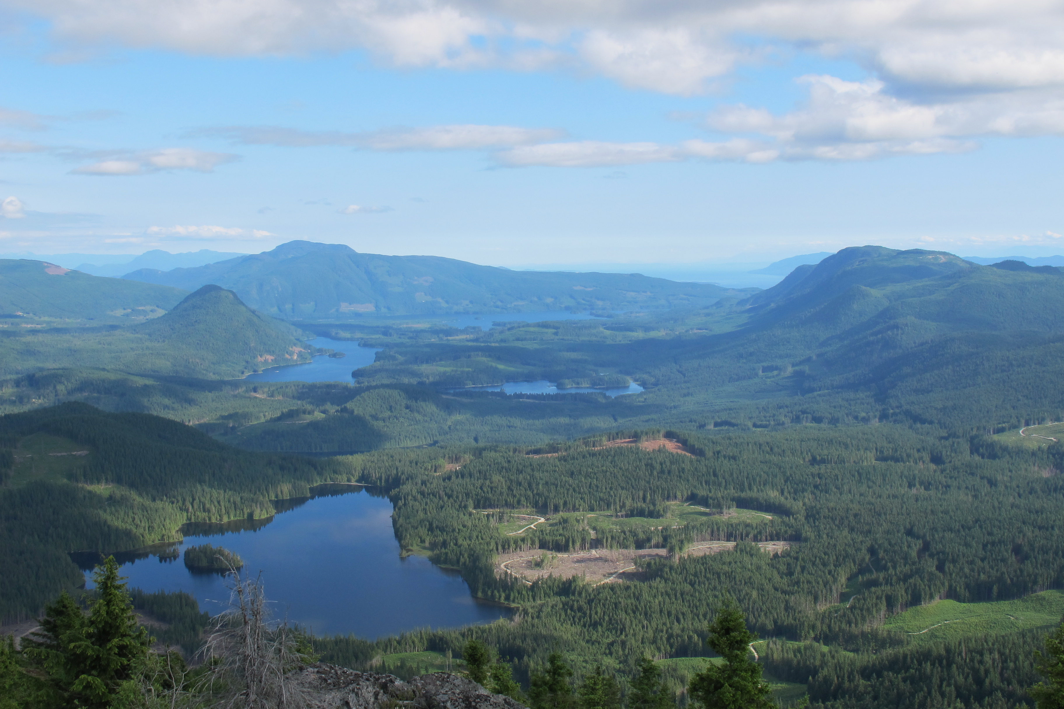
Make it to the top of Tin Hat Mountain and you will be rewarded with 360-degree views of more than two-dozen lakes. Plus you’re half way to finishing the trail! Photos courtesy Eagle Walz
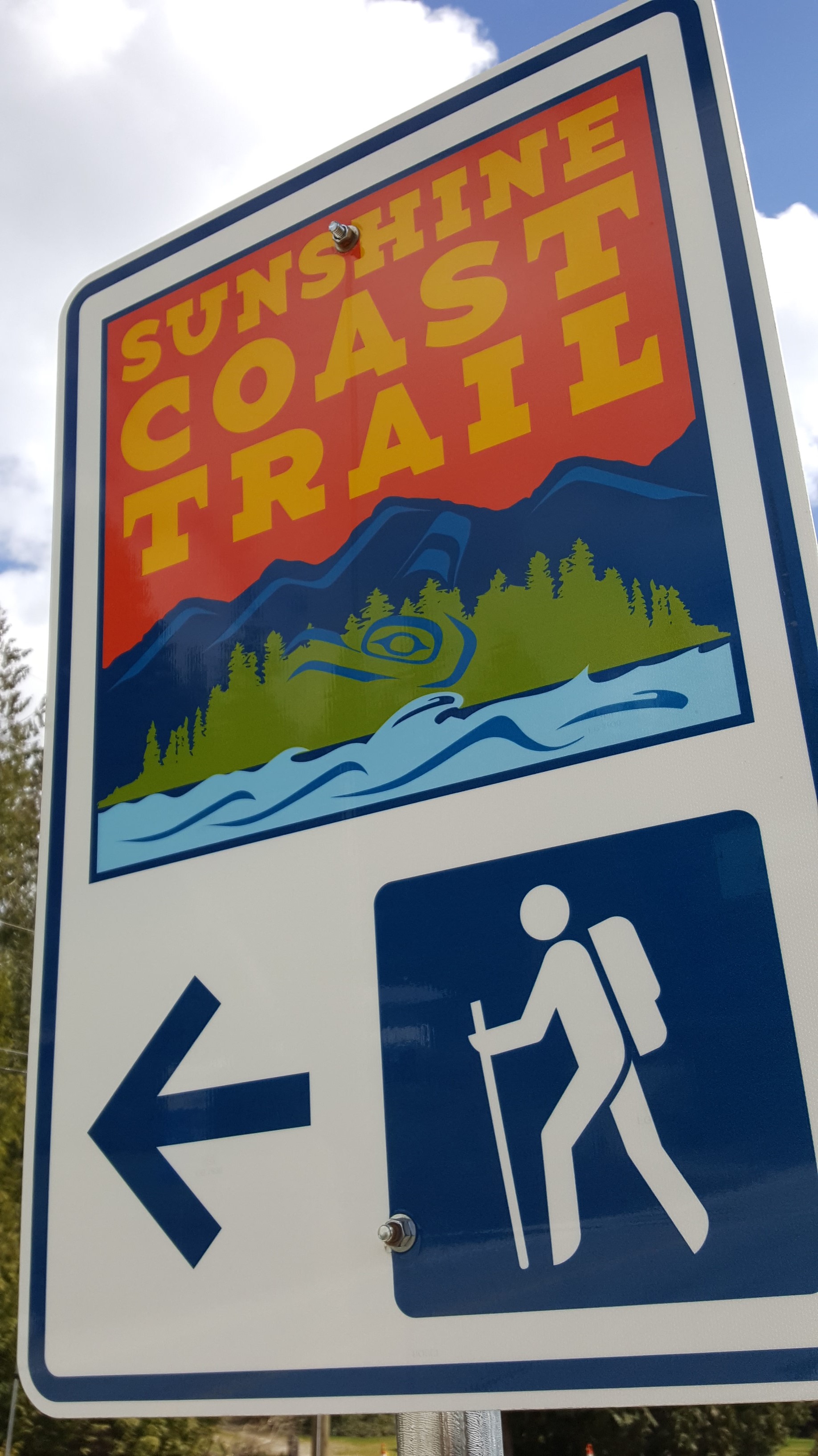
Connecting Sarah Point, near Lund, to the ferry terminal at Saltery Bay, the 180-kilometre Sunshine Coast Trail now ranks among the greatest hiking trails in the world, according to Explore Magazine’s Top-50 list. Not only is it more than twice the length of the West Coast Trail on Vancouver Island, it’s Canada’s longest hut-to-hut hiking trail, and it’s free!
The trail’s mix of old growth forest, mountain peaks and sandy shoreline, attract thousands of visitors from around the world each year. Fifteen beautifully constructed huts en route provide overnight accommodation on a first-come, first-serve basis.
“It’s beginning to be seen as an economic driver in Powell River,” says Eagle Walz. “It’s the biggest recreational tourism resource we have.”
Walz is a trailblazer, one of a handful of outdoor enthusiasts who in 1992 realized that accessible old growth on the Upper Sunshine Coast was fast disappearing. They formed the Powell River Parks and Wilderness Society (PRPAWS), a non-profit committed to setting aside protected areas on a trail sufficiently unique to lure locals and tourists alike.
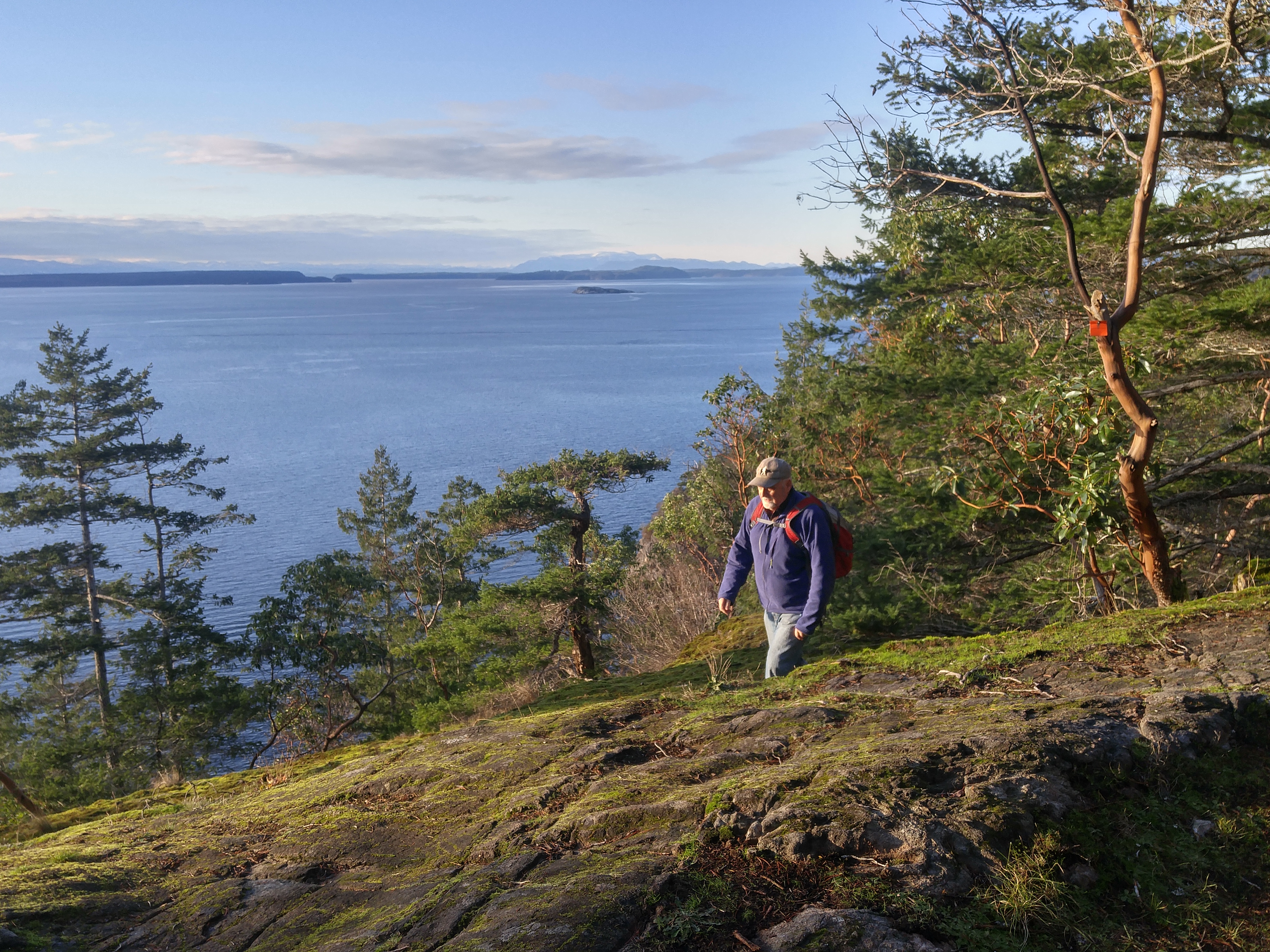
Eagle Walz in his element, hiking the Sunshine Coast Trail. Walz is a co-founder of the Powell River Parks and Wilderness Society, the non-profit behind the trail’s creation and upkeep.
PRPAWS mobilized volunteer work parties and began connecting the bushwhacked paths, deactivated roads, and disused railway grades left behind by a century of logging. In some places that meant constructing bridges – some 120 feet long – to ford creeks and rivers. They found enduring allies in a group of bloody old men, otherwise known as the BOMB (Bloody Old Men’s Brigade) squad. Comprising mostly retirees, many of whom practiced their trades at Powell River’s paper mill, the BOMB squad helped build bridges and huts, and are still counted upon for help in the trail’s never-ending maintenance.
The first time I interviewed Eagle for a story back in 2000, he was fending off criticism from a variety of sources over liability issues and the environmental concerns about sensitive wildlife areas. Walz and his cohorts had run into a host of jurisdictional challenges, too. Crown forest land, private land owned by logging companies, and Tla’amin Nation land are among the eight jurisdictions through which the trail crosses.
Seventeen years ago, he addressed those questions with a question of his own: “Would the trail have been built if we’d settled all these issues first?”
When I caught up with Eagle earlier this year, that question at least, appeared to have been answered. “You couldn’t start this trail now and try and make this happen,” says Eagle. “But that doesn’t mean the logging companies won’t stop logging. Western Forest Products, with their tree farm licence, they are the biggest interest. We manage to work together and eke out considerations. I only wish it would be a bigger buffer along the trail than we get most of the time.”
That buffer can be from 10 to 30 metres, sometimes more. Occasionally, the trail must be relocated in places. Overall, says Eagle, compromise and varying levels of protection ensure the trail’s viability.
“Our vision is that in 100 years, we’ll have no more logging near the trail,” he says. “It will be designated an old growth trail to be enjoyed by future generations. It needs someone to be the champion for it. We’re hopeful the younger generation will take over and certainly a lot of younger people are using it. People of all ages.”
Perhaps more challenging to PRPAWS is pressure on the trail from non-hikers.
“Mountain biking is very popular here, as it is everywhere else. The pressure is always to turn something into something else. But a multi-use trail wouldn’t have the same appeal as a single-use trail. We’re struggling to remain a hiking trail only because that’s what’s given us the edge in the market place. That’s what is bringing people by the thousands from all over the world to Powell River.”
In the meantime, trail maintenance keeps Eagle busier than ever. Ten years retired as a teacher, Eagle says he has time to enjoy the trail, but it’s usually when he’s part of a work party. The day I call him, he’s about to leave on just such a mission – a five-night trip to Confederation Lake, a steep section of the trail in Inland Lake Park, north of Powell River.

Eagle Walz takes in the view from the hut atop Tin Hat Mountain.
It’s a favourite spot, he says, before adding: “I think usually where I’m working, I like that part the best.” Eagle’s other cherished locations include Tin Hat Mountain with its 360-degree views of more than two-dozen lakes; and Mount Troubridge, popular for its magnificent stands of Douglas fir and yellow-cedar old growth.
When Eagle’s not on the trail, he’s writing about it – though not in the way he might have envisaged in 1972, when he moved to Powell River to write poetry: “I write hundreds and hundreds of emails,” he says in a deadpan voice. “That’s basically the extent of my writing.”
- Visit http://sunshinecoast-trail.com/ for everything you need to know about planning a trip, including the definitive guide to the trail, written by – who else? – Eagle Walz.
The Missing Link: Connecting the Coast to Squamish
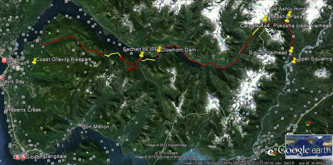
Yellow sections on this Google Earth map indicate about 10 kilometres of work needed to complete a trail connecting Sechelt with Squamish.
The map looks straightforward at first. As the crow flies, little more than 50 kilometres separate Sechelt and Squamish. Then you notice contour lines, crammed together like intense low-pressure systems, numerous splashes of white, indicating icy peaks, and deep blue streaks showing alpine lakes and ocean inlets. In between are green valleys that never seem to quite connect. Old logging roads, new hydroelectric projects, powerlines and pipelines present an extra layer of complexity revealed by Google Earth.
A cursory Internet search turns up more than 100 years of failed attempts to build a road system between the Sunshine Coast and “the mainland”.
So when Geoff Breckner tells me he’s about 10 kilometres away from completing a 75-kilometre trail connector, I’m interested.
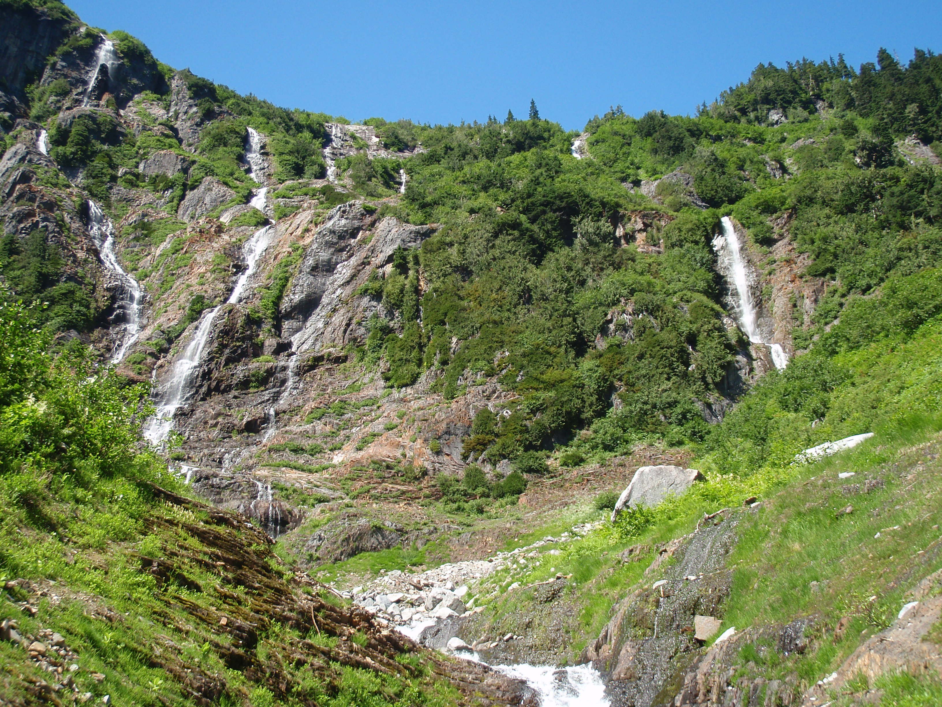
If successful, the trail would reveal a side of the Sunshine Coast unfamiliar to most residents, including a series of spectacular waterfalls between Pokosha Pass and Clowhom Valley. All photos courtesy Geoff Breckner
“With 10 capable guys and permission it could be finished in a week or two,” Breckner tells me by phone from Squamish. “But there are channels to go through, rules to be followed … funding.”
Breckner is recovering from major back surgery. When his doctor advised him to exercise he began hiking into the backcountry near his home in Squamish. The 53-year-old estimates he spent 200 hours during the last two summers working on the Squamish end of the trail.
A self-described “mountainbiking nut,” and “bush rat,” Breckner grew up in Deep Cove when the sport was still a novelty. He opened Pemberton’s first bike store, High Line Cycles, in 1994. A trail connecting Squamish with the Sunshine Coast makes a lot of sense, he says.
“I thought this was a great place for a bike trail. I knew there were logging roads up there and I researched as much as I could, checking out the feasibility of a route to Sechelt.”

Geoff Breckner’s tent at the south side of Pokosha Pass, near Mount Jimmy Jimmy.
Visit Breckner’s Facebook site ‘Squamish to Sechelt Trail’ and you’ll see a Google Earth image of the proposed route. From Upper Squamish and the Ashlu River Road, the route first heads north over existing trail through 4,000-foot Pokosha Pass before heading south, then due west following Clowhom Lake to Salmon Inlet, skirting the Tetrahedron Provincial Park, and on towards Sechelt via the Coast Gravity Bike Park.
About 55 kilometres of double track roads, and 20 kilometres of single track trails make up the route, says Breckner. The 10 kilometres still to be cleared comprise three sections of one kilometer, four kilometres and five kilometres.
“Once complete, it would be a long ride – two days for most people, but I hope to have a hut or shelter so people don’t need a tent and can travel light,” says Breckner. “The main problem would be lack of use, rather than overuse. The more use the better, to keep trail maintained and established.”
Breckner has received numerous offers of help from this side of the divide. Doug Feniak of Tillicum Bay is among those pledging assistance.

A self-described mountainbiking nut, Geoff Breckner rarely goes anywhere without his ride.
Feniak grew up riding with Breckner in Deep Cove. “It was a dream of ours when we were young, to be able to ride from Squamish to the Coast,” says Feniak. “We hiked into the Tetrahedron in August, looking for the best way. It’s super steep into Thornhill Creek but it shouldn’t be too bad after that because it’s old roads covered with Alders.”
Trails are in the Feniak family’s blood. Wife Jessica Huntington and son Linden both build trails, the latter professionally. Daughter, Holly, was 2012 downhill mountainbike Junior World Champion.
Doug says he expects to have a group working on this end of the trail in the fall.
“It would certainly be good for tourism here and I could see the B.C. Bike Race using it,” says Feniak.
Long-time local trailbuilder, Richard Culbert, says a trail to Squamish is “common sense”.
Culbert built the trail to the summit of Mt. Elphinstone, opening it on his 70th birthday. Now at 75, he’s busy clearing a trail up 4,700-foot Polytope Peak, which connects with Rainy River Road and Port Mellon due south. He believes that a trail from Squamish stands a better chance of completion if it veers south to Port Mellon, rather than to Sechelt.

Salmon Inlet from the top of Gray Creek Forest Service Road, looking north across Thornhill towards Clowhom valley. It’s about 60km from here to upper Squamish.
“The trail I’m working on is about a kilometer from a logging road, which appears to connect with this route,” says Culbert pointing at a printed version of Breckner’s route. “It also avoids Thornhill Creek [near Salmon Inlet] where the road is covered in alders.”
Warren Hansen concurs. “That gap after Salmon Inlet is some of the most rugged terrain I’ve ever walked in,” says Hansen, forester/area manager for Chartwell Consultants and an avid trailbuilder. “A lot of that area was logged in the 60s and 70s, so we’re talking about logging roads half a century old – many of which have been heavily deactivated and are covered in alder.
“I admire following an idea, but I worry about the sustainability of it,” adds Hansen. “The skeptical side of me thinks that there won’t be enough people using it. It will need to be on a lot of people’s bucket lists to make it sustainable.”
Hansen identifies with Breckner on one level.
“I believe in unfettered access to crown land. You live in the city, you can’t do this and that, but you have spoon-fed amenities. In a rural environment you don’t have those amenities, but you do have unfettered access to crown land. You can hike it, bike it, pick mushrooms in it, build trails. So you use it as you see fit, knowing that one day, it might be logged.”
Perhaps the person most excited about a possible connection is Bjorn Enga. The Granthams Landing-based filmmaker is the founder of Kranked, an online store for electric-assisted mountainbikes. They may upset purists, but bikes capable of climbing mountains in minutes, as opposed to hours, are catching on, says Enga.
“I’ve been riding on the Coast since 2000, and it’s an amazing coastline,” he says. “Suddenly, I’m thinking how much more I can see up there riding an e-bike. Imagine how phenomenal it would be to offer overnight tours with a fully charged battery for the next day.
“The Sea-to-Sky Corridor could become the e-bike capital of the world.”
Enga is helping Breckner with route planning and believes that trail completion is a matter of when, not if.
“Geoff goes way back to the start of mountainbike culture, before the glamour of the parks,” says Enga. “He’s done the hard part and one way or another, the trail will happen.”
In the meantime, some adventurers will continue to blaze their own trails. It seems as though everyone on the Sunshine Coast knows “a guy” who knows a route to Squamish. But their identity can be as elusive as the route.

More falls in the backcountry between Squamish and the Sunshine Coast.
Not so, Todd Lawson and friends, whose epic three-day trek from Lake Lovely Water, Squamish, to Sechelt via Clowhom Lake and Salmon Inlet, was featured in a 2014 issue of Mountain Life magazine. The trio packed inflatable stand-up paddleboards for the trip, which featured untold hours of bushwhacking through endless alder roots and Devil’s Club – an experience Lawson described in the story as “torture”. (He also wrote of the route, “It looked good on a laptop.”)
A different hazard awaited Denis Rogers of Sechelt, and fellow Coasters Mark Guignard and Al Jenkins, who hiked to Squamish in 2004 after being dropped by boat at the head of Narrows Inlet.
“It took us five days,” says Rogers, whose group followed a route from the head of Tzoonie Valley to a 4,800-foot pass, and then down to Falk Creek and a logging road leading to the Ashlu River and Squamish beyond.
“The third day was an interesting one,” recalls Rogers. “I fell in a lake and broke my watch, and Mark, the only one of us who didn’t bring bear spray, had an encounter with a black bear. Mark was about 20 yards ahead of us, picking his way through the boulders, when we shouted to him that a bear was taking an interest in him.
“The bear started down towards him, but then turned back. We suggested that perhaps the bear had been deterred by an offensive smell.”
Some hazards you won’t find on any map.
- To contact Geoff Breckner, email capnbreak@yahoo.ca or visit his Facebook site, Squamish to Sechelt Trail.
Whistler mild and wild
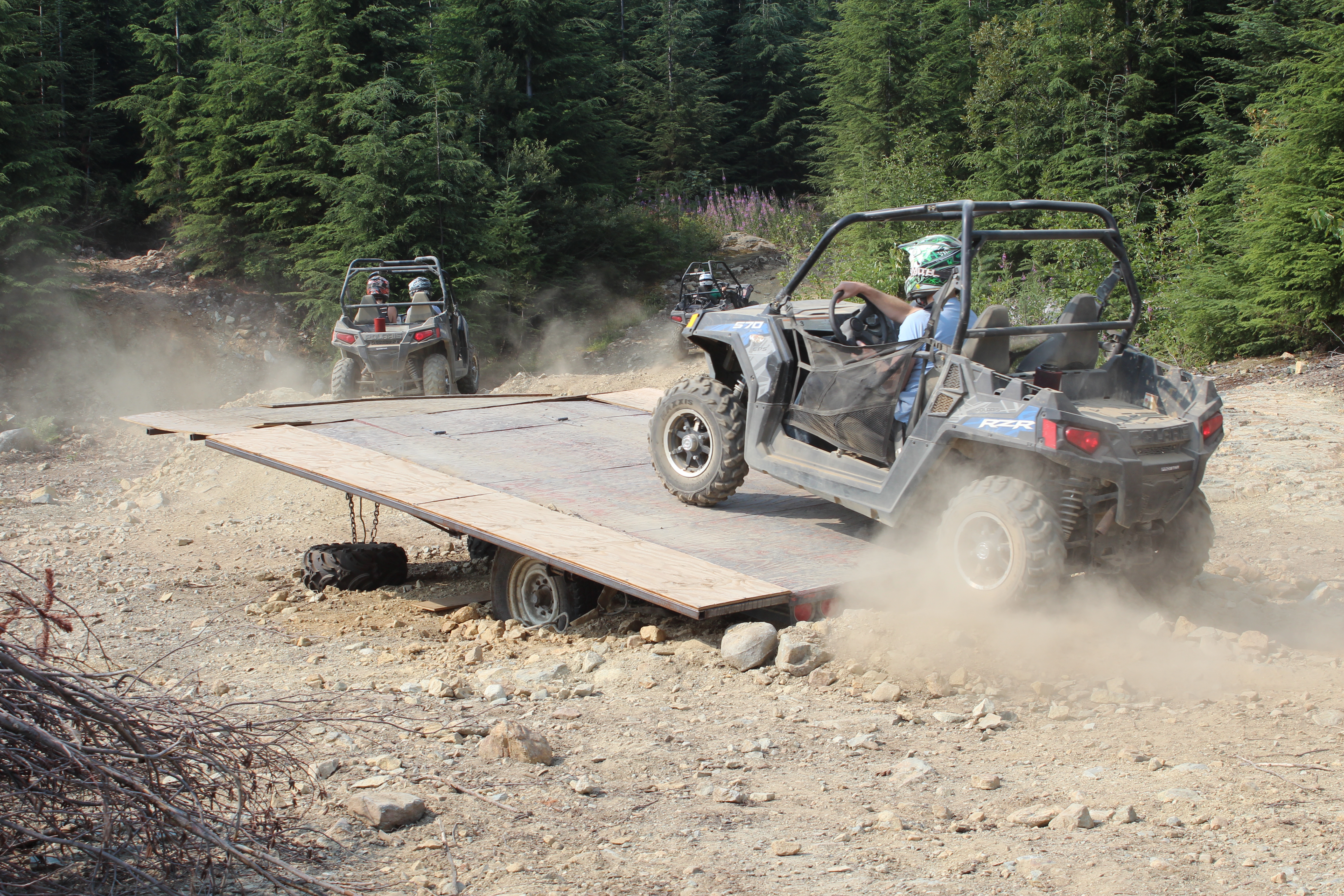
The Polaris 570 cc RZR has never met an obstacle it didn’t like.
Close to the highest point of Fairmont Chateau Whistler Golf Course, the Blackcomb River dissects the manicured greenery and drops the air temperature about 15 degrees. The water’s arrived directly from the Horstman Glacier atop Blackcomb peak, which explains the cold and why this is a popular spot during record-breaking heat.
“It’s like instant air conditioning,” says a friend. It also makes the mosquitoes disappear, I think to myself. At the clubhouse, we’d just finished an indulgent meal, which somehow featured bacon in every course, including the caesar aperitif and the Nanaimo bar dessert. The temperature is still in the 20s and haze from the Pemberton forest fire lingers.
If you like your adventure on the mild side, the Golf Clubhouse Dinner and Nature Tour is right up your fairway. Enjoy dinner as the sun sets behind Rainbow Mountain, then board a golf cart for a nature tour of the course. The carts are equipped with GPS, which seems like overkill to me, (how hard can it be to navigate 18 numbered holes?) but given the 400-foot climb in places, I’m happy not to be walking.

The Fairmont’s Golf Clubhouse Dinner and Nature Tour covers several food groups, especially bacon.
Even for non-golfers like me, there’s much to enjoy about the tour, which traverses creeks and milky-green glacier-fed ponds, ancient Douglas Fir, and granite bluffs. Sadly, the bears aren’t out tonight, but a protective mother grouse is strutting around the 13th hole with her three chicks in tow. The course has erected bat houses close to the 18th green, with more in mind than just encouraging wildlife. A single brown bat eats up to 1,000 mosquitoes in an hour!
If you like your adventure in something more agile than a golf cart, a RZR (that’s “Razor” when you say it out loud) Tour will safely push you a little further beyond your comfort zone. RZRs are four-wheeled, off-road vehicles capable of negotiating the gnarliest of boulder-strewn logging roads and creek beds. The morning after our night at the golf course, we rise early at the Fairmont Chateau Whistler for a RZR Alpine Sunrise Tour by The Adventure Group (TAG). Alongside its ever popular Superfly Ziplines at Cougar Mountain, about 10 minutes’ drive from Whistler, TAG’s RZR tours are an exhilarating way to quickly find yourself in the rarefied air, high up in Whistler’s backcountry.
With a guide driver at the front and ‘spotter’ at the back, we each board a Polaris 570 cc RZR and make final adjustments to dust masks, goggles and helmets. With no rain for weeks, and exposed to the elements but for a roll cage, we’re about to get extremely dusty. And as I turn the ignition key sparking the engine to life, I can’t help thinking a GPS would be better suited to a RZR than a golf cart.
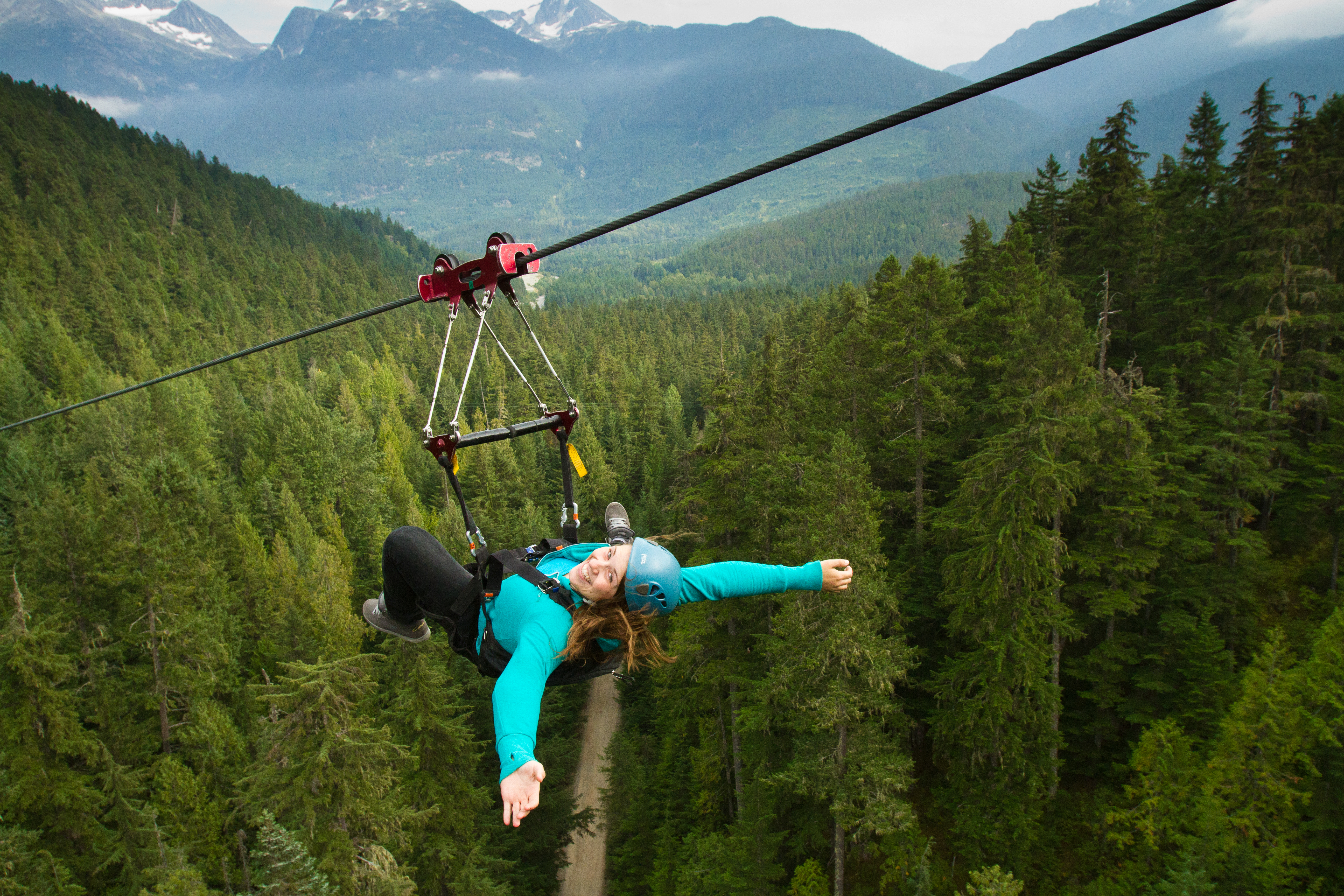
For the ultimate in thrill rides, Superfly Ziplines are hard to beat.
It’s a bumpy ride – extremely bumpy in places – but with one foot firmly applied to the gas, the RZR is capable of clearing anything in its path. The bucket seats absorb most of the jolts and on the steep bits, the brakes respond better to a few taps than to sustained pressure.
Our tour takes us through Ancient Cedars and Showh Lakes, hiking areas known for giant trees and good fishing. Lupins and fireweed are everywhere at about 3,500 feet, where we park to admire hazy views of Mount Currie and the Soo River below. It’s a world away from the bustle of Whistler village, and I begin to think of how much fun it would be to ride a snowmobile up here. Back on this tour, there’s more fun to be had at an obstacle course created in a clearing that features a teeter totter, berms, and steep embankment trails for those who hold their nerve.
During the 15-kilometer, two-and-a-half tour, we rarely exceed 25 km/h, such is the heavy going on Cougar Mountain’s rocky roads. But bouncing around on trails all but impassable to any other vehicle is half the fun. For anyone with $11,000 to spend and a quiet air strip, RZRs can accelerate from 0 to 35 mph in four seconds, and clock over 80 mph!
For similar speeds at less money, you might want to check out the Superfly Ziplines.
If you go
Fairmont Chateau Whistler offers numerous summer packages, including golf vacations and the B.C. resident accommodation offer, which saves 15% off best rates. Visit fairmont.com/whistler
The Adventure Group’s Alpine Sunrise Tour at Cougar Mountain costs $219 (2-seater) or $319 (4-seater). TAG also offers a two-hour Wilderness Ride and a three-hour B.C. Tour. For details, call 1 855 824-9955 or visit tagwhistler.com/
Fairmont’s Golf Clubhouse Dinner and Nature Tour includes a three-course dinner and costs $69 per adult ($35 per child) and is available Mondays, Tuesdays, and Wednesdays. Call 604 938-8000.
