Archive for the ‘Sechelt’ Category
The Trail Collector

Creator of sunshine-coast-trails.com Becky Wayte is probably the Sunshine Coast’s most avid nature bather.
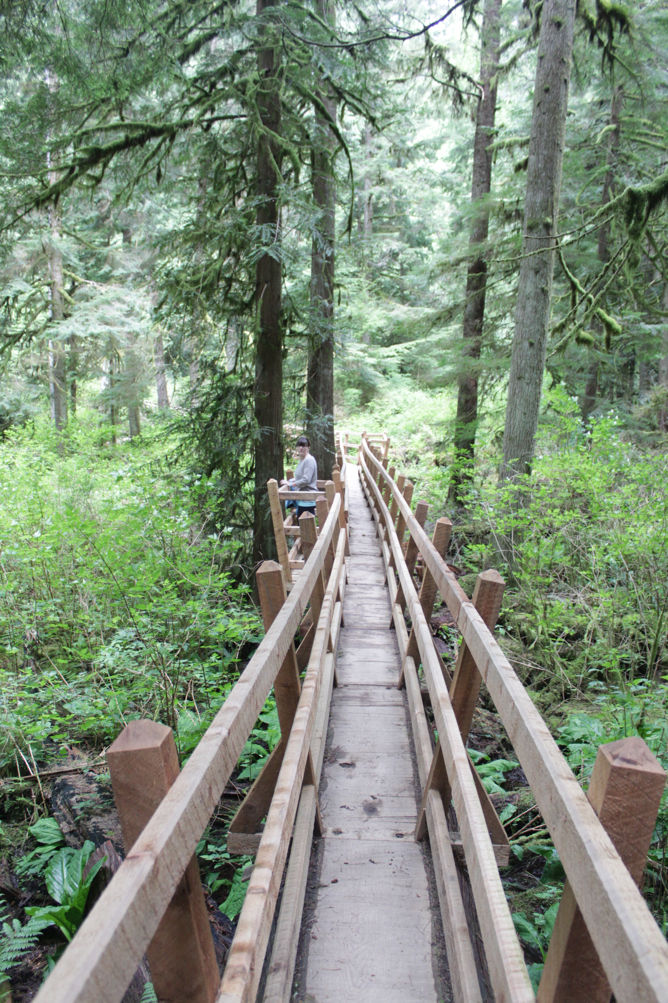
You might call Becky Wayte a wanderer. Almost every day for the last 20 years, Becky has hiked or biked a trail somewhere on the Sunshine Coast. It wasn’t until a couple of years ago though, that she became a collector.
Some people collect stamps; others baseball cards. Becky collects trails, maps them with a GPS, and documents them on sunshine-coast-trails.com, a website she created for outdoor enthusiasts. The site lists hundreds of trails, from Langdale to Earl’s Cove, with descriptions, maps, difficulty ratings and useful links. She has her favourites – three of which she describes in her own words in a sidebar to this story.
In 2011, hiking three to four hours a day, almost every day, Becky managed to map almost all of the Sunshine Coast’s trails in six months. She’s been updating her collection ever since. The Coast is home to some prolific trail builders, it seems.
“I actually thought it would take me a couple of years,” she tells me. “But I quickly realized that I’m a little obsessive. When I start something, I need to see it through to the end.”
But the truth is, collecting trails never ends. New trails are always springing up and some remain well-guarded secrets. In a recent interview with pinkbike.com, local mountain-bike phenom, Holly Feniak, describes the Coast’s trails as: “Dreamy. Loamy, mossy, bouncy, incredibly green, and in the secret spots … all that and steep.”
Cliff Gilker Park, Roberts Creek.
She might have added ‘never-ending’!
“For heaven’s sake, stop building trails,” Becky laughs, when I ask her about the Coast’s trail builders. “I actually love finding new trails and I admit, there might be the odd one I don’t know about. I’m always trying to keep up!”
For a moment, we think we may have found a new one. It’s an unusually hot day in May and we’re walking through a dusty trail off Field Road in Wilson Creek. We’re accompanied by Cody, a large, lovable dog from the nearby SPCA where Becky volunteers each week as a dog-walker. The path veers past someone’s back yard and into the forest.
“Let’s take a look,” says Becky, in her element. A few minutes later we come to a dead-end. Cody looks at us expectantly and we return the way we came. So what inspired Becky to take on this labour of love?
“I have three dogs and one has issues with other dogs, so I wanted to find new trails to hike where there weren’t so many people,” she says. “There were few websites, but they only featured the most popular hikes, places like Mount Daniel, so I decided I’d do it myself.”
Becky’s well qualified. Not only does she love the outdoors, but she learned to build websites through her work teaching computer courses in the Adult Basic Education Program at Capilano University in Sechelt. With the website established, Ryan Robertson, a Squamish-based app developer, who specializes in creating trail applications for iPhones and Androids, contacted Becky. Becky provided the GPS (Global Positioning System – the satellite navigation application) data and Ryan created the app. Trailmapps: Sunshine Coast costs $10 and is available at the Apple Store and Google Play.
For old-school trail lovers, she’s also created waterproof trail maps that are available in Gibsons at Spin Cycles, and in Sechelt at Source for Sports, the Sechelt Visitors’ Centre, and Off The Edge Adventure Sports.
Outdoors, technology couldn’t be further from Becky’s mind. While she’s always hiked to combat weight gain, she’s also convinced of nature’s therapeutic benefits. The Japanese have a name for it: shinrin-yoku, or forest bathing. Becky cites Japanese research, which points to the many benefits of simply being in nature – lower blood pressure, higher creative aptitude and boosted immune systems.
“I prefer the term ‘nature-bathing’ because I find just being out in nature makes me feel better. I always come home feeling better than when I left.”
Well, almost always.
Becky sheepishly recalls one particular hike that went awry, much to her husband’s despair. “I was hiking up Elphinstone and I’d let people know where I was going and what time I’d return. It took a lot longer than I’d expected though and my phone died.
“I got back around 7:45 p.m. – not the 5 p.m. I’d told my husband. He was pretty mad.”
The experience didn’t sour Becky’s love of Mount Elphinstone. In fact, the Mount Elphinstone Summit Trail ranks in her three favourite hikes and bikes. (See below.)

Kinnikinnick Park, West Sechelt.
Sidebar
My Three Favourite Hikes & Bikes, by Becky Wayte
Mount Elphinstone Summit Trail (hike only)
This is a long, fairly difficult climb, but the view at the very top is worth it. The trail to the top can be accessed from the top of Sprockids or via some feeder trails off B & K logging road in Roberts Creek. If you take your time and enjoy a picnic and rest at the top, this hike will likely take you five or six hours. Make lots of noise or wear a bell so the bears hear you coming.
Ruby Klein Traverse – Suncoaster Trail (hike or bike)
Beautiful views of Ruby Lake and a hand carved bench greet you at the highest point along the trail. Easy to make a whole day trip out of this even though the hike itself will probably only take you a couple of hours. You can visit the Iris Griffiths Centre, take a swim in Klein Lake and there is even a feeder trail down to the Ruby Lake restaurant (Trattoria Italiano).
McNeill Lake Circle Route (hike or bike)
This is one of my favourite destinations in the summer months because I always combine a bike ride with a swim. The lake itself is not that well known so often no one else is there, especially on weekdays. There are several trails that connect to create a loop around the lake, with access to the lake from a couple of spots. I park on Middlepoint Forest Service Road and take Copper Head, Dry Feet, a logging road, Old Pole Road and back to Copper Head. There is a short trail off the logging road just north of Dry Feet that takes you into the lake. This is an excellent place to ride your mountain bike if you have pre-teen kids or you just want a fairly flat ride (we don’t have many flat rides on the Coast). Hiking it probably takes about 1.5 hours and by bike about an hour, unless you stop to enjoy a swim.
For the definitive web guide to the Sunshine Coast’s trails, visit http://www.sunshine-coast-trails.com.
Heart of green
Sechelt Rotarians, Tom Pinfold (right) and Mick van Zandt on the trails of Kinnikinnick.
Shirley Macey didn’t have time to waste. When she wasn’t coaching kids, she was raising a family, working as a Gibsons RCMP dispatcher, and lobbying local government for more recreational space.
Somehow she found time every week to climb Soames Hill with a garbage bag to pick up other people’s litter.
“She was pretty amazing,” remembers her son Darin. “I didn’t think much of it growing up; now I don’t know how she did it.”
At the southern end of the Coast, 14 hectares of Soames Hill Regional Park are named after Shirley Macey. No doubt she would be proud of the soccer fields, the wheelchair-accessible playground and Frisbee golf course. Shirley – or Sam (an acronym of her full name, Shirley Amelia Macey) to her friends – was a dedicated volunteer whose legacy is by no means unique.
Shirley Macey, Maryanne West, Ted Dixon, Cliff Gilker and Hackett are – to name a few – venues so familiar to most of us that it’s easy to forget that they were also people. Ted Dixon, for example, worked tirelessly for self-government for the Sechelt Indian Band before dying in a car crash in 1981. Maryanne West was the backbone of community TV and so many volunteer projects before dying at age 90 in 2008.
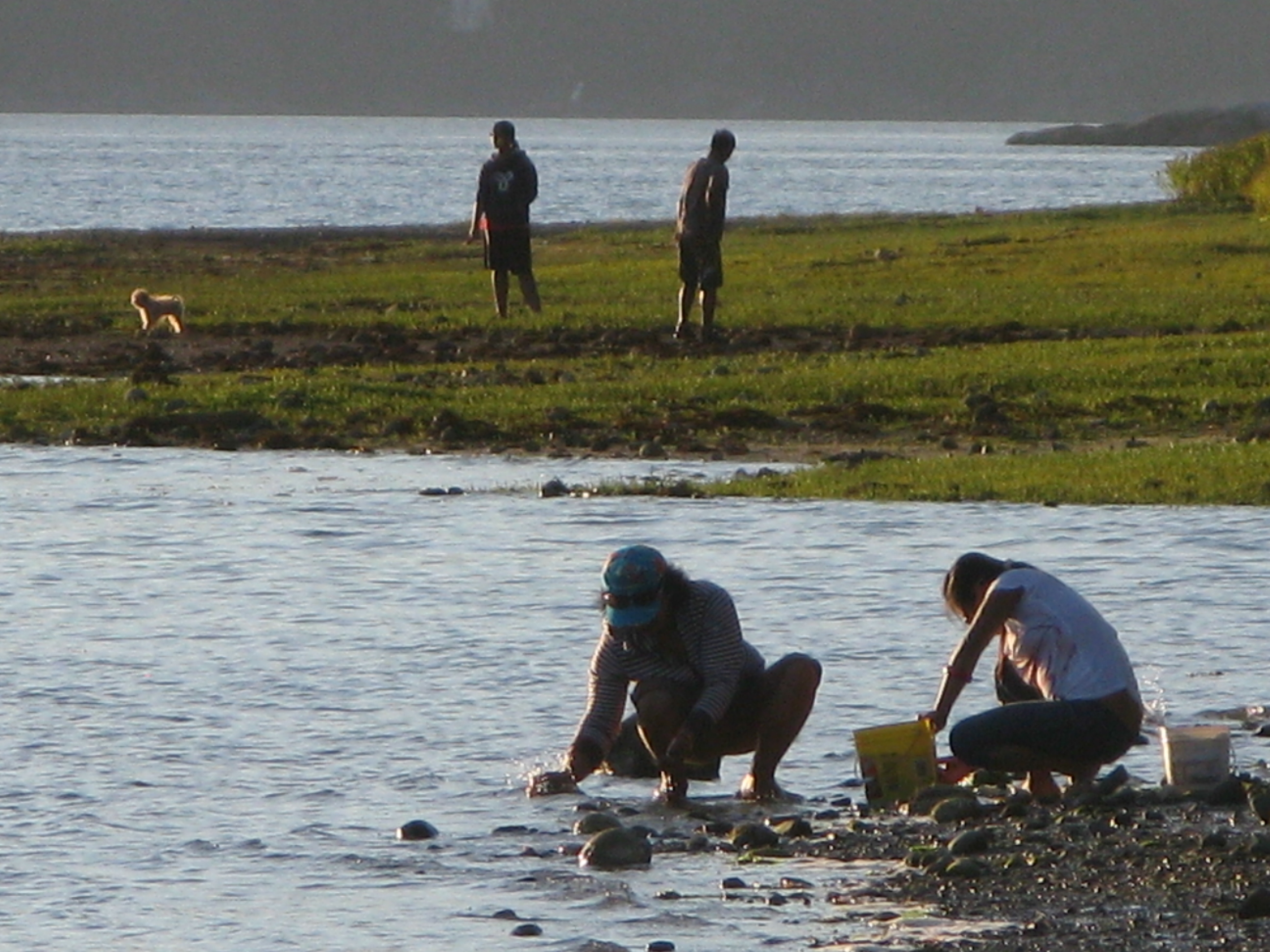
Scavenging the shoreline at Porpoise Bay. For parks and beaches, Sunshine Coasters are spoiled for choice.
And not all parks bear a family name. Brothers Memorial Park in Gibsons was named for logging contractors, Al and George Jackson who donated the land.
Today, volunteers continue to be the lifeblood of the Sunshine Coast’s parks and trails. In fact, the parks system wouldn’t work without them.
“We totally rely on volunteerism,” says Sunshine Coast Regional District parks planning coordinator, Sam Adams. “We wouldn’t be able to do what we do without it.”
For the SCRD that means mobilizing volunteer help in bigger parks like Dakota Ridge, where members of the Dakota Ridge Advisory Committee have been particularly helpful. Volunteers also help the SCRD maintain trails at Soames Hill, most recently working to improve the wooden stairs. Now the regional district is hoping to cultivate more volunteer assistance with an adopt-a-trail program.
“Part of our work plan for 2013 is to develop a more robust volunteer program,” says SCRD parks planning coordinator, Susan Mason. “We have kilometres and kilometres of trails to maintain, so people willing to document changes on a regular basis are helpful to us.”
The government-volunteer relationship is similar elsewhere on the Coast. District of Sechelt parks supervisor Perry Schmitt is grateful for the work of several trail building groups, as well as established service clubs.

Sunshine Coast Lions Club president Len Schollen at the site of the Lions’ next project, an accessible viewing deck in the corner of Mission Point Park where the beach and Chapman Creek meet.
“The Lions Club has been instrumental in making improvements to Mission Point park and the Sechelt Rotary Club has been assisting in rebuilding decks throughout Kinnikinnick forest trails,” says Schmitt. He also cites the work of the Sechelt Groves Society at the Heritage Forest trails, and the Sunshine Coast Natural History Society, which tends to Sechelt Marsh.
On a cold blustery day, Sunshine Coast Lions Club president Len Schollen shows me work completed on the Mission House deck and the next project – an accessible viewing deck in the corner of Mission Point Park where the beach and Chapman Creek meet.
“We’re basically waiting for some decent spring weather to build the viewing platform and a hard-surface ramp leading up to it,” says Schollen, surveying the footings already in place. “There’ll be a railing around it and hopefully some signs with information about the salmon run and pointing out places like Mount Arrowsmith.”
Why are Schollen and other Lions members involved in the project? “We serve, is the Lions’ motto,” says Schollen simply. “We try to make this a better place to live.”
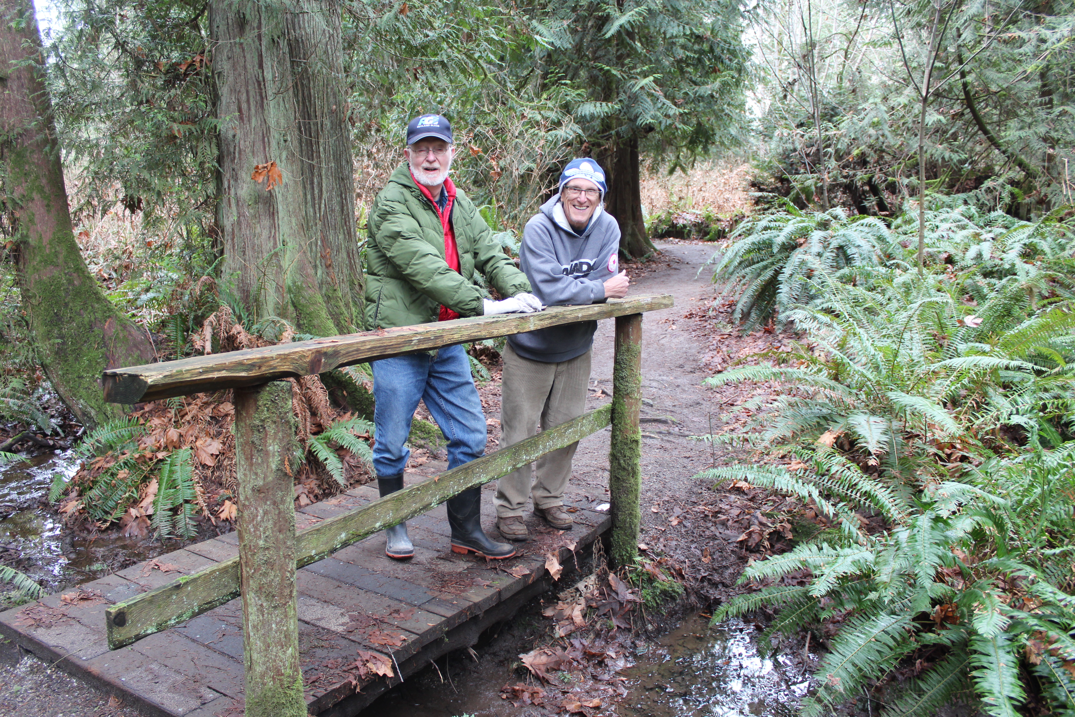
It’s a sentiment shared by Sechelt Rotarians, Tom Pinfold and Mick van Zandt, when I meet them on the trails of Kinnikinnick park.
“We wanted to work on small projects where a few people could work for a few hours on something with lasting benefit,” says Pinfold. “We’d much prefer to let the District allocate their resources to new things instead of maintenance.”
With other Rotarians, the pair has replaced and built cedar bridges and decks throughout Kinnikinnick’s trails during the last three years. Topped with roofing tiles, the decks are essential given the drainage issues on multi-use trails in a popular park. The new bridges should be good for at least 10 years, reckons Pinfold. (Elsewhere in Kinnikinnick park and at Sprockids park in Langdale, Capilano University students hone their trail-building skills as part of the Mountain Bike Operations Certificate curriculum.)
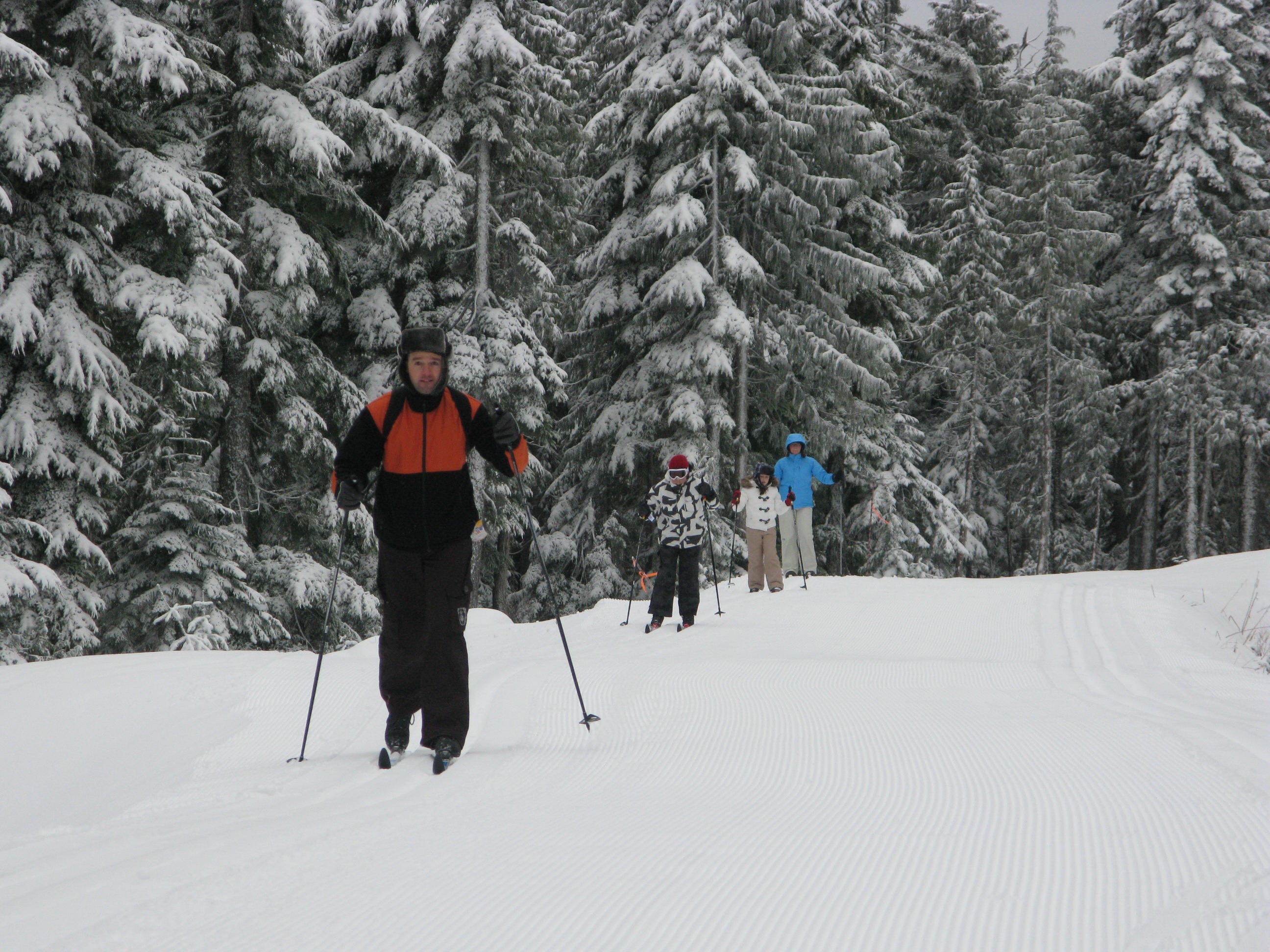
There are 13 kms of groomed trails for cross-country skiers on Dakota Ridge, yet another Coast playground.
Pinfold and van Zandt have also worked on a wheelchair accessible deck at Halfmoon Bay’s Trout Lake and a viewing platform and trail in Roberts Creek’s Cliff Gilker park.
Elsewhere, volunteers continue to make the Sunshine Coast a great place to play. If you’re searching for the heart of the Sunshine Coast you’ll find it in any park or trail. From Pender Harbour’s Lions Park (the best soccer field on the Coast) to the mountain bike trails of Sprockids Park in Langdale, outdoor recreation thrives because people care enough to make it happen.
People like Shirley Macey.
Shirley didn’t live to see the park she’d fought for named in her honour. Just months after retiring from the RCMP and paying off her mortgage, she died of cancer in 1998.
“I didn’t realize until I was older that quite a few people called her mom,” recalls Darin, who has four kids of his own now. “I met all these people I knew at her service who thought of her as a surrogate mother.
“My kids are certainly proud of the park’s name. It’s too bad she died so young.”
Trail Mix
There are numerous opportunities to get involved in outdoor volunteering. Here are a few websites where you’ll find more information.
http://secheltlionsbc.lionwap.org/
email tony@whiskeyjacknaturetours.com for the Sunshine Coast Natural History Society
Thanks to the Sechelt Community Archives and the Sunshine Coast Museum and Archives for their help in researching this feature.
White and wild on Dakota Ridge

If cross-country skiing is a little slow for you, tobogganing should get your adrenaline racing on Dakota Ridge.
Forty minutes ferry-ride from West Vancouver, the Sunshine Coast is better known for The Beachcombers, scout camps and verdant shorelines. People don’t typically associate this 140-kilometre peninsula with snow. But there it is, several feet of the stuff, just waiting to be played in.
You just have to look up.

There's cross-country skiing for all ages on Dakota Ridge.
Poking through the clouds about 1,200 metres above the beaches and pretty parks is Dakota Ridge, one of the best cross-country ski destinations in the last place you’d expect to find it. Between November and March, if it’s raining at sea level, there’s a good chance it’s snowing up there.
And it’s only a 20-minute drive from sea level.
“You can come up for a couple of hours and be in a completely different world,” says Craig Moore, a cross-country skier and long-time member of the Dakota Ridge Winter Recreation Society, a non-profit group working to promote the area. “For cross-country skiing it beats anywhere on the west coast.”
It’s pretty good for tobogganing and snowshoeing, too.
A 620-hectare (1,532 acres) plateau atop a working watershed, Dakota Ridge offers a rolling landscape of stunted old growth hemlock and yellow cedar. On a clear day you can see the North Shore mountains, the Gulf Islands and Vancouver Island beyond – even Mount Baker down in Washington State.
There are 13 kilometres of groomed trails for cross-country skiers on Dakota Ridge.
Cross-country skiers will find 13 kilometres of groomed Nordic trails, all of them signposted and colour-coded according to degree of difficulty. Professional engineer Reidar Zapf-Gilje, who prepared Callaghan Valley’s 2010 Nordic Olympic course, designed Dakota Ridge’s trail network.
“In many cross-country skiing areas you’re skiing through woods and you don’t see too much,” says Zapf-Gilje.
“Dakota Ridge is way up there in terms of esthetics. Its real strength is its potential for recreation and citizen [cross-country] races.”
Jamie Mani hopes that potential will be realized. Mani owns Alpha Adventures, a Wilson Creek outdoor-adventure store specializing in guided snowshoe and cross-country ski touring on the Ridge.

When it's not snowing, the views from Dakota Ridge can be spectacular.
“One of the great things about this place is its proximity to so many other activities,” says Mani. “Someone can literally be out snowshoeing in the morning up in the mountains and then golfing or kayaking in the afternoon.
“And for Nordic skiing we have excellent potential because of great snowfall and a blend of flat and rolling trails. We have been skiing on the Ridge as late as May in previous years.”
Snowshoers will find their own trails and there’s plenty of room for hiking and tobogganing. You’ll find a parking lot, warming hunt and toilet at the trailhead.
The turnoff for Dakota Ridge is at the top of Field Road in Wilson Creek, about half way between Gibsons and Sechelt, and 20 kilometres drive from BC Ferries’ Langdale terminal. For many years, the unplowed access road to Dakota’s trailhead made it a ridge too far for some. In recent years the 11-kilometre road has been upgraded to allow for regular plowing, but four-wheel drive vehicles equipped with chains are still the way to go.
Or take advantage of Alpha Adventure’s shuttle service.
- To learn more about Dakota Ridge, visit http://www.scrd.ca/Dakota-Ridge
- For road updates and snow conditions on the Ridge, visit www.suncoastcentral.com/outdoor-reports.asp.
- To book cross-country ski lessons, a guided tour, equipment rentals or shuttle service up to Dakota Ridge, call Alpha Adventures at 1 604 885-8838 or visit www.outdooradventurestore.ca

Treasure in our midst

Geocaches are hidden everywhere, often right under our noses!
